100th Anniversary of the 1913 Great Lakes White Hurricane
Nov. 8, 2013 PLYMOUTH VOICE

They called it the “White Hurricane.
The Great Lakes Storm of 1913, the 100th anniversary of which is this month, exacted a toll far greater than that of the gale that sank the Edmund Fitzgerald in 1975. The former storm battered the lakes from Nov. 7 to 10, and remains the region’s worst natural disaster on record. Twelve freighters sank, 19 more were wrecked, and up to 300 sailors died. Vessels foundered on every Great Lake except Ontario.
Triggered by a convergence of storm fronts similar to those that generated Hurricane Sandy in 2012, the 1913 storm’s winds, which reached 140 kilometres (86 mi) per hour and raised waves higher than 10 metres (32 ft.) in some waters, also devastated land. Roughly 75 per cent of the forest between the areas just north of Lake Superior and the southeast end of Georgian Bay were flattened, and more than half a metre of snow smothered cities and towns on both sides of the border.
The storm was first noticed on Thursday, November 6, on the western side of Lake Superior, moving rapidly toward northern Lake Michigan. The weather forecast in The Detroit News called for “moderate to brisk” winds for the Great Lakes, with occasional rains Thursday night or Friday for the upper lakes (except on southern Lake Huron), and fair to unsettled conditions for the lower lakes.
Around midnight, the steamer Cornell, while 50 miles (80 km) west of Whitefish Point in Lake Superior, ran into a sudden northerly gale and was badly damaged. This gale lasted until late Monday, November 10, almost forcing Cornell ashore.
On Friday, the weather forecast in the Port Huron Times-Herald of Port Huron, Michigan, described the storm as “moderately severe.” By then, the storm was centered over the upper Mississippi Valley and had caused moderate to brisk southerly winds with warmer weather over the lakes. The forecast predicted increased winds and falling temperatures over the next 24 hours.
At 10:00 a.m., Coast Guard stations and United States Department of Agriculture (USDA) Weather Bureau offices at Lake Superior ports raised white pennants above square red flags with black centers, indicating a storm warning with northwesterly winds. By late afternoon, the storm signal flags were replaced with a vertical sequence of red, white, and red lanterns, indicating that a hurricane with winds over 74 mph (119 km/h) was coming. The winds on Lake Superior had already reached 50 mph (80 km/h), and an accompanying blizzard was moving toward Lake Huron.
By Saturday, the storm’s status had been upgraded to “severe”. The storm was centered over eastern Lake Superior, covering the entire lake basin. The weather forecast of the Port Huron Times-Herald stated that southerly winds had remained “moderate to brisk”. Northwesterly winds had reached gale strength on northern Lake Michigan and western Lake Superior, with winds of up to 60 mph (97 km/h) at Duluth, Minnesota.
A false lull in the storm (a “sucker hole”) allowed traffic to begin flowing again, both down the St. Marys River and up Lake Erie, and the Detroit and St. Clair rivers, into Lake Huron. Gale wind flags were raised at more than a hundred ports, but were ignored by many ship captains. Long ships traveled all that day through the St. Marys River, all night through the Straits of Mackinac, and early Sunday morning up the Detroit and St. Clair rivers.

By noon on Sunday, weather conditions on lower Lake Huron were close to normal for a November gale. Barometric pressures in some areas actually began to rise, bringing hope of an end to the storm. The low pressure area that had moved across Lake Superior was moving northeast, away from the lakes.
The Weather Bureau had issued the first of its twice-daily reports at approximately 8:00 a.m.; it did not send another report to Washington, D.C. until 8:00 p.m. This proved to be a serious problem: the storm would have the better part of a day to build up hurricane forces before the Bureau headquarters in Washington, D.C., would have detailed information.
Along southeastern Lake Erie, near the city of Erie, Pennsylvania, a southern low-pressure area was moving toward the lake. This low had formed overnight, so was absent from Friday’s weather map. It had been traveling northward and began moving northwestward after passing over Washington, D.C.
The intense counterclockwise rotation of the low was made apparent by the changing wind directions around its center. In Buffalo, New York, morning northwest winds had shifted to northeast by noon and were blowing southeast by 5:00 p.m., with the fastest gusts, 80 mph (130 km/h), occurring between 1:00 p.m. and 2:00 p.m. Just 180 miles (290 km) to the southwest, in Cleveland, winds remained northwest during the day, shifting to the west by 5:00 p.m., and maintaining speeds of more than 50 mph (80 km/h).
The fastest gust in Cleveland, 79 mph (127 km/h), occurred at 4:40 p.m. There was a dramatic drop in barometric pressure at Buffalo, from 29.52 inHg (999.7 hPa) at 8:00 a.m. to 28.77 inHg (974.3 hPa) at 8:00 p.m.
The rotating low continued along its northward path into the evening, bringing its counterclockwise winds in phase with the northwesterly winds already hitting Lakes Superior and Huron. This resulted in an explosive increase in northerly wind speeds and swirling snow. Ships on Lake Huron that were south of Alpena, Michigan—especially around Harbor Beach and Port Huron in Michigan and Goderich and Sarnia in Ontario-were battered with huge waves moving southward toward St. Clair River.
From 8:00 p.m. to midnight, the storm became what modern meteorologists call a “weather bomb”. Sustained hurricane-speed winds of more than 70 mph (110 km/h) ravaged the four western lakes. The worst damage was done on Lake Huron as numerous ships scrambled for shelter along its southern end. Gusts of 90 mph (140 km/h) were reported off Harbor Beach, Michigan. The lake’s shape allowed northerly winds to increase unchecked, because of the lower surface friction of water compared to land, and the wind following the lake’s long axis.
In retrospect, weather forecasters of the time did not have enough data or understanding of atmospheric dynamics to predict or comprehend the events of Sunday, November 9. Frontal mechanisms, referred to then as “squall lines”, were not yet understood. Surface observations were collected only twice daily at stations around the country, and by the time these data were collected and hand-drawn maps created, the information lagged actual weather conditions by hours.
On Monday morning, the storm had moved northeast of London, Ontario, dragging lake effect blizzards in its wake. An additional 17 inches (43 cm) of snow were dumped on Cleveland, Ohio that day, filling the streets with snowdrifts 6 feet (2 m) high. Streetcar operators stayed with their stranded, powerless vehicles for two nights, eating whatever food was provided by local residents. Travelers were forced to take shelter and wait for things to clear.
By Tuesday, the storm was rapidly moving across eastern Canada. Without the warm lake waters, it lost power quickly. This also meant less snowfall, both because of the fast motion of the storm and the lack of lake effect snow. All shipping was halted on Monday and part of Tuesday along the St. Lawrence River around Montreal, Quebec.
Along the shoreline, blizzards shut down traffic and communication, causing hundreds of thousands of dollars in damage. A 22-inch (56 cm) snowfall in Cleveland, Ohio, put stores out of business for two days. There were four-foot (122 cm) snowdrifts around Lake Huron. Power was out for several days across Michigan and Ontario, cutting off telephone and telegraph communications. A recently completed US$100,000 Chicago breakwater, intended to protect the Lincoln Park basin from storms, was swept away in a few hours.[21] The Milwaukee harbor lost its entire south breakwater and much of the surrounding South Park area that had been recently renovated.
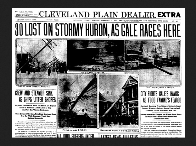
After the final blizzards hit Cleveland, the city was paralyzed under feet of ice and snow and was without power for days. Telephone poles had been broken, and power cables lay in tangled masses. The November 11 Plain Dealer described the aftermath:
“Cleveland lay in white and mighty solitude, mute and deaf to the outside world, a city of lonesome snowiness, storm-swept from end to end, when the violence of the two-day blizzard lessened late yesterday afternoon.”
William H. Alexander, Cleveland’s chief weather forecaster, observed:
“Take it all in all—the depth of the snowfall, the tremendous wind, the amount of damage done and the total unpreparedness of the people—I think it is safe to say that the present storm is the worst experienced in Cleveland during the whole forty-three years the Weather Bureau has been established in the city.”
The greatest damage was done on the lakes. Major shipwrecks occurred on all but Lake Ontario, with most happening on southern and western Lake Huron. Lake masters recounted that waves reached at least 35 feet (11 m) in height. Being shorter in length than waves ordinarily formed by gales, they occurred in rapid succession, with three waves frequently striking in succession. Masters also stated that the wind often blew in directions opposite to the waves below. This was the result of the storm’s cyclonic motion, a phenomenon rarely seen on the Great Lakes.
In the late afternoon of November 10, an unknown vessel was spotted floating upside-down in about 60 feet (18 m) of water on the eastern coast of Michigan, within sight of Huronia Beach and the mouth of the St. Clair River. Determining the identity of this “mystery ship” became of regional interest, resulting in daily front-page newspaper articles. The ship eventually sank, and it was not until early Saturday morning, November 15, that it was finally identified as the Charles S. Price (this was the first time in Great Lakes History that a fully loaded ore carrier had been capsized). The front page of that day’s Port Huron Times-Herald extra edition read, “BOAT IS PRICE — DIVER IS BAKER — SECRET KNOWN”. Milton Smith, an assistant engineer who decided at the last moment not to join his crew on premonition of disaster, aided in identifying any bodies that were found.
The final tally of financial loss included $2,332,000 (US) for vessels totally lost, $830,900 for vessels that became constructive total losses, $620,000 for vessels stranded but returned to service, and approximately $1,000,000 in lost cargoes. This figure did not include financial losses in coastal cities.
The storm had several long-term consequences. Complaints against the USDA Weather Bureau of alleged unpreparedness resulted in increased efforts to achieve more accurate weather forecasting and faster realization and communication of proper storm warnings. Criticism of the shipping companies and shipbuilders led to a series of conferences with insurers and mariners to seek safer designs for vessels. This resulted in the construction of ships with greater stability and more longitudinal strength. Immediately following the blizzard of Cleveland, Ohio, the city began a campaign to move all utility cables underground, in tubes beneath major streets. The project took half a decade.
|News Plymouth Michigan
Historic source and photos: Canadian Geographic, National Weather Service (NOAA), and Wikipedia


